|
Snapshots from Jersey by Christina Brodie, UK |
Jersey, along with the other Channel Islands, was retained as a personal possession of the British Crown since 1204, when Normandy was lost to France. From the point of view of its position, it has more in common with Normandy and Brittany, yet a number of extraordinary phenomena combine to produce a unique landscape and flora. This article describes some of the plant life and geology from the western side of the island, observed from mid- to late April.
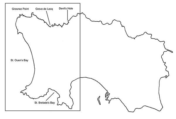
The western side of the island covered in this article.
From the air, and on a map, it appears as though large semicircular bites have been taken out of the coastline, where the sea has pounded rather unyielding igneous rocks into curvaceous, sandy beaches. The geology is unique in consisting of ancient igneous and sedimentary rocks, overlain by very recent glacial deposits. There are large intervening periods about which we know nothing; the Mesozoic era, which represents most of the evolution of terrestrial life and included the age of dinosaurs, is not represented. As a result there are very few fossils on Jersey, excepting those left by the activities of early man.
The area has been subjected to periodic incursions by the sea, and also invaders, whose building activities have been largely left untouched. The resulting prehistoric dolmens, the remains of medieval castles, and concrete watchtowers and bunkers dating from the WWII German occupation, alternate along the coastline. A spate of building in the 17th and 18th centuries by cod-fishing tycoons led to a characteristic form of architecture, after a Queen Anne style. Jersey was never self-supporting in terms of arable farming; a number of apple-orchards were planted in the 17th and 18th centuries to produce cider. Nowadays, farmers compete to produce the earliest Jersey Royal potatoes - costly because of the small plot sizes, and manual labour involved. Giant cabbages, which grow on stalks up to ten feet high or more, and which were used historically as construction materials, are also in evidence.
Southern and western beaches: St. Brelade's/ St. Ouen's Bay
St Brelade's Bay, on the southern coast of the island, and St Ouen's Bay, which stretches nearly the whole of the Atlantic coast, proved to be rich in pickings for the phycologist. Their treasure-trove of intertidal debris yielded over 20 different types of seaweed. However, this is still only a fraction of the total; over 200 or so species have been recorded offshore!
The seaweed has been collected for centuries (a process called racking) by locals for use as a soil improver. Kelp, from the kelp forests offshore, is littered throughout the intertidal zone. The kelp forests play host to and provide shelter for a number of other different species.
Seaweeds identified: (The accompanying pencil drawings, from a battered sketch-book).
Green: Codium, Ulva lactuca (sea lettuce).
Brown: Ascophyllum nodosum (knotted wrack)? Desmarestia ligulata, Dictyota dichotoma, Halidrys siliquosa (pod weed or sea oak)? Laminaria hyperborea (kelp), Sacchorhiza polyschides (furbelows), Sargassum muticum.
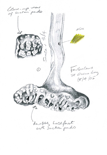
The hollow holdfast of furbelows, covered in suction pads.
Red: Calliblepharis jubata, Calosiphonia vermicularis?, 2 Ceramium sp.? Chondrus crispus (carragheen or Irish moss), Corallina officinalis (coralweed), Furcellaria lumbricalis, Gastroclonium ovatum, Laurencia pinnatifida (pepper dulse), Lomentaria articulata, Mastocarpus stellatus (also referred to as carragheen!), Palmaria palmata (dulse), Plocamium cartilagineum, Plumaria elegans?
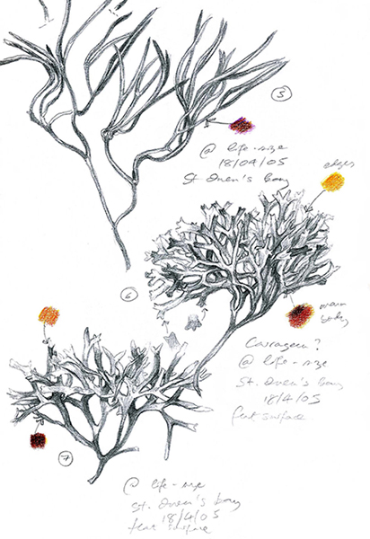
Top to bottom: Furcellaria lumbricalis, Chondrus crispus, Mastocarpus stellatus (with spear-shaped ends to the frond).
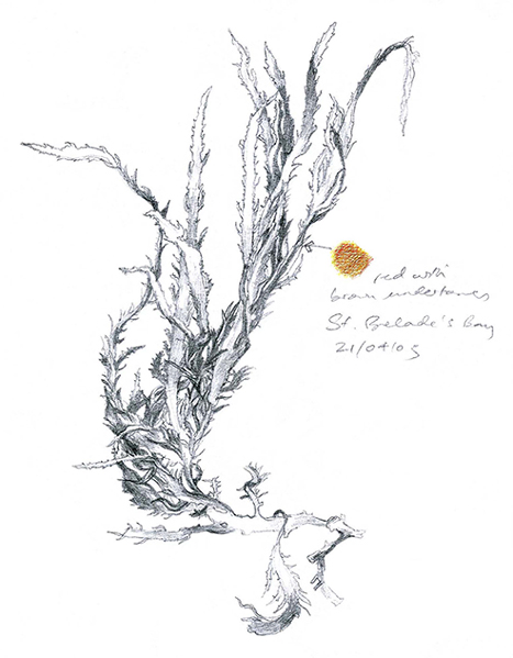
Calliblepharis jubata.
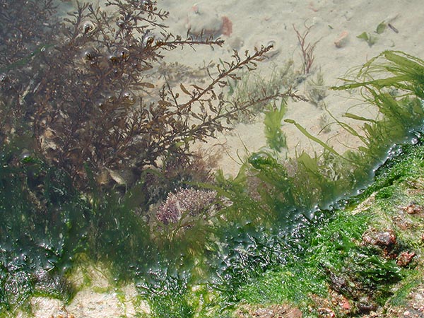
A tidal pool in St. Brelade's Bay, host to a variety of different seaweeds. Upper left: Sargassum muticum; bottom, right: Ulva lactuca, covering Corallina officinalis near middle of picture.
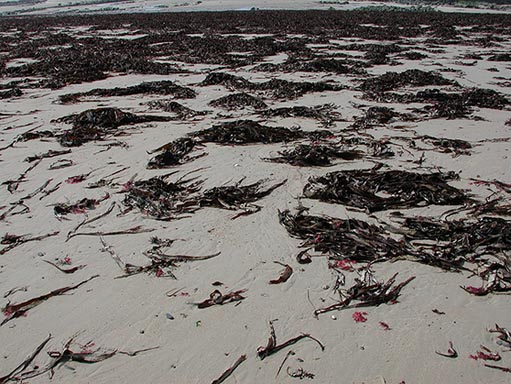
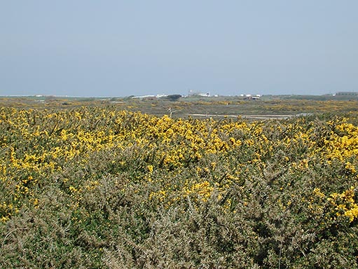
Kelp, spread as far as the eye can see, at the northern end of St. Ouens' Bay.
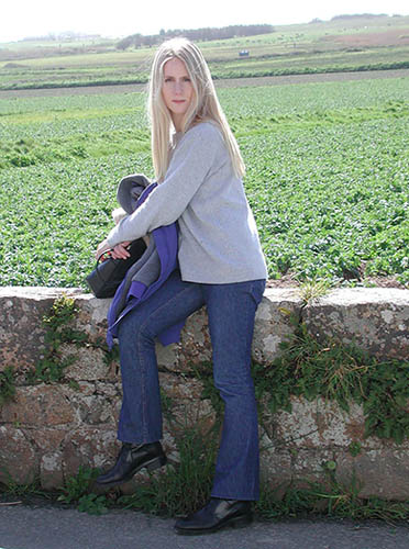
The author (trying to squint in the sun), against a background of Jersey Royals. The view here stretches towards the Atlantic coast, encompassing St. Ouen's Bay and Corbiere Point (on the left-hand side of the picture). Just inland from St. Ouen's Bay is a nature reserve and ancient dune complex. The higher ground shown below, seen from the coastal road, is actually a raised beach formed by isostatic uplift during tectonic movement, and fluctuating sea levels. Sand has been blown from the bay area as much as 2 km inland.
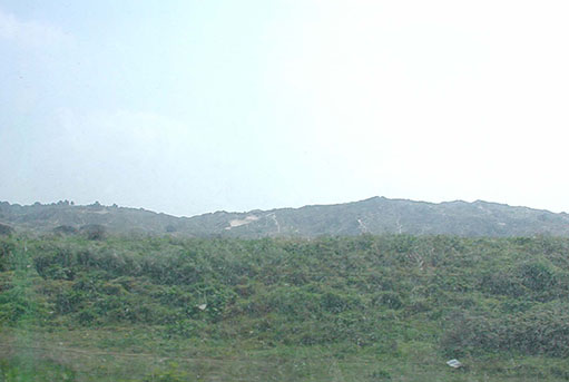
A raised beach/plateau formed by isostatic uplift.
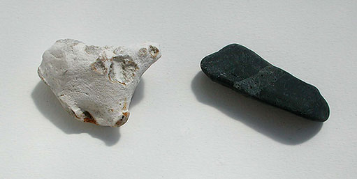
Chert, (flint), a form of chalcedony, and a fragment of some of the most ancient rocks in Jersey, Brioverian shale, collected in St. Ouen's Bay.
St. Ouen's Bay to Grosnez Point: Maritime and moorland flora
A walk from St. Ouen's Beach over the moor to Grosnez Point, in the north-western corner of the island, yielded a number of species that, although not exclusive to Jersey, were good representations of typically maritime and moorland flora. Many were substantially undersized, which was possibly due to the exposed coastal conditions and soil/rock type; this area consists entirely of granite, which has not been covered by Recent sediments. Where my fingers have been included for scale, the breadth of one fingernail equals exactly 1 cm.
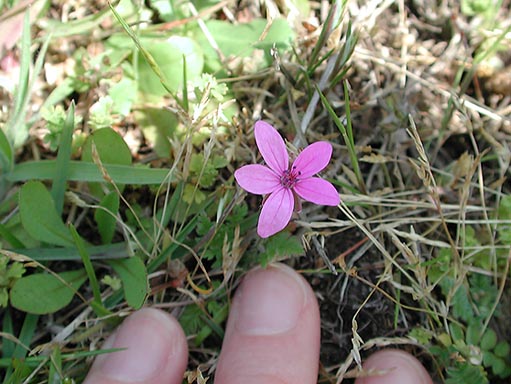
Erodium circutarium, Common Stork's Bill. White forms may also be found.
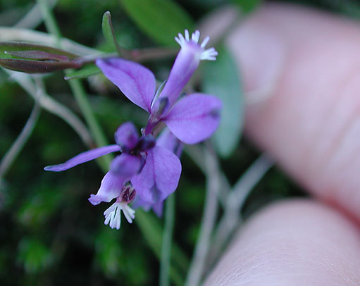
Polygala serpyllifolia, Heath Milkwort, a perennial with beautiful tiny blue flowers only just visible among the heather. This is the more usual form but pink, white or paler blue forms can also be found. Up close the flowers can be seen to consist of a tube containing the floral parts, flanked by two flattened perianth segments.
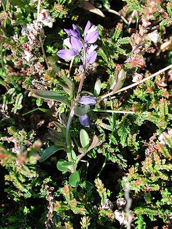
A whole-plant view of Polygala serpyllifolia, illustrating its creeping nature.
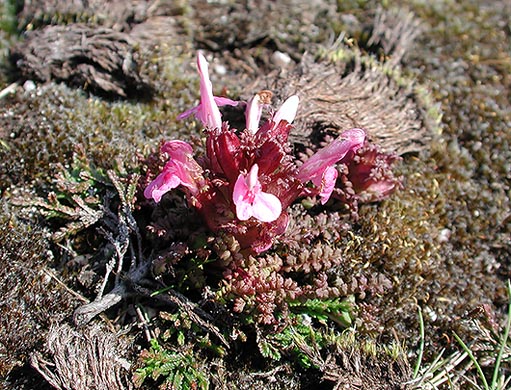
Pedicularis sylvatica, or lousewort, a typical plant of heaths, moor and bog. This was found to be very low-growing, probably only about 5 cm high (although it can grow to 25 cm), and arranged in a squat rosette. Leaves/bracts appear reddish in this photograph but can equally be tinged with yellow-green.
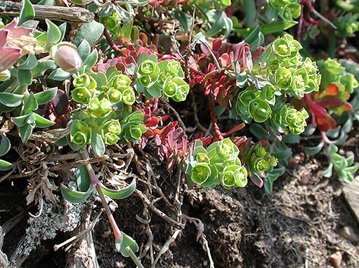
Euphorbia portlandica, Portland Spurge, with Silene vulgaris ssp. maritima , Sea Campion, towards the upper left of the picture.
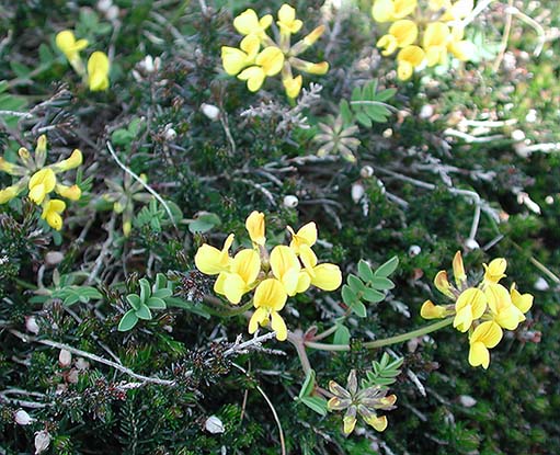
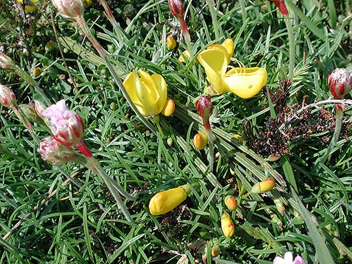
Hippocrepis comosa, Horseshoe Vetch.
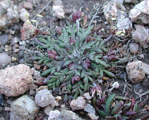
Plantago coronopus, Buck's Horn Plantain, found at Grosnez Point, and easy to miss unless one focuses on the ground! The rosette in this instance was only about 2 cm across; usually the leaves are better developed. Flowers are small and inconspicuous with very dominant floral parts. Up close it can be seen that the leaves are slightly succulent and hairy, an indicator of the plant's preferred habitat of exposed coasts, shingle and cliff-tops.
Cytisus scoparius ssp. maritimus (Broom) and Armeria maritima ssp. maritima (Thrift).
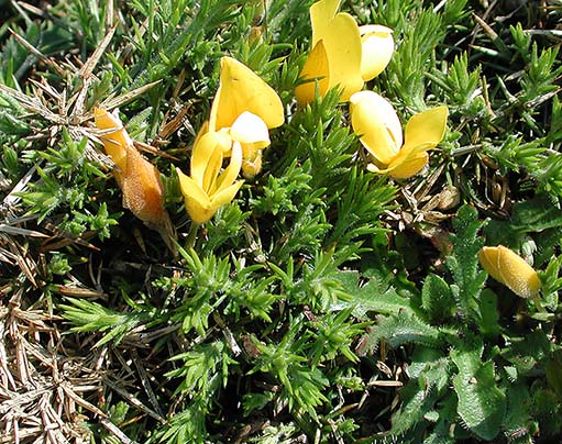
Ulex europaeus, Gorse. Notice the similarities between the flowers of gorse, broom, and the horseshoe vetch above!
A view of the moor, part of the way towards Grosnez Point.
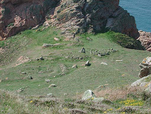
The prehistoric dolmen visible about halfway along the cliff-path.
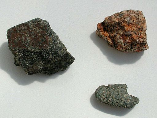
Granite-type rocks from the area. At upper right is a granite with the characteristic pinkish colour given by orthoclase feldspar. The rock at left is probably diorite, a mixture of granite and gabbro, a darker and more basic igneous rock. The smaller fragment at lower right is possibly intermediate between the two.
Greve de Lecq to Devil's Hole
A peculiar geological phenomenon can be viewed by walking approximately 3 miles along the coast from Greve de Lecq beach (or a comparatively shorter distance from Greve de Lecq Vineyard). The phenomenon in question is an area where rock behind the cliff has slumped to form a shaft (hence the name Devil's Hole), which has been systematically eroded and eventually connected to the sea through erosion of caves in the cliff on the seaward side.
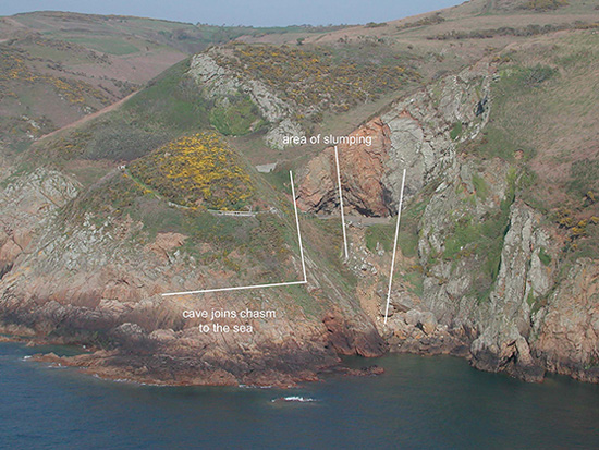
Devil's Hole.
Approximately halfway along this walk is a similar and, it was universally agreed, more picturesque, geological structure. The origins are possibly the same as those at Devil's Hole, with the difference that the hole has been enlarged to create a stack, Ile Agois. Presently this is inaccessible, though building foundations and the recovery of Roman and Dark Age coins indicate early settlement.
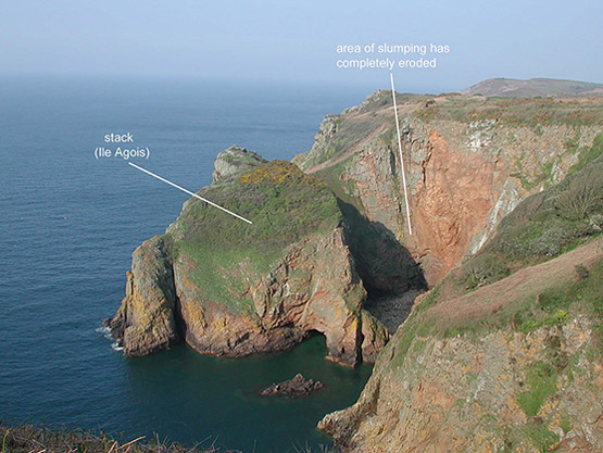
Ile Agois.
Recommendations
A visit to La Hougue Bie, the oldest and most complete burial mound in Europe, is highly recommended. The original Neolithic passage was covered in rubble to increase the structure's stability; the mound also serves as one of the highest points in the area. A chapel was built on top of the mound in medieval times, and its ruins incorporated into an 18th-century folly, which for some time served as a private home. The folly was dismantled and the chapel reconstructed in the first half of the 20th century, but further archaeological work on the mound was interrupted by the German occupation and the building of a bunker into the mound, diametrically opposite the Neolithic passage. More about La Hougue Bie can be found here:
http://www.bbc.co.uk/jersey/about_jersey/historic_sites/history_houguebie.shtml
The grounds also house a display of archaeological artefacts and a very detailed exhibition of Jersey's geology. More general information about Jersey's history and wildlife can be found at Jersey Museum in St. Helier (near the bus station), and at the Societe Jersiaise offices around the corner.
The following book, available at the museum sites, provides an excellent and concise introduction to Jersey geology. It incorporates suggested walks, and details which sites should not be collected from! All the rock fragments shown in this article were already loose.
Similarly, the seaweeds were collected from intertidal debris, and picking of flowering plants was avoided by using a digital camera in close-up mode and making sketches.
My especial thanks to Margaret Long, of the Societe Jersiaise, and Mike Guiry, of the British Phycological Society, for identifying the plants and seaweeds shown here.
Societe Jersiaise:
http://www.societe-jersiaise.org/_pages/_sections.html
Mike Guiry's Seaweed site:
http://www.seaweed.ie/defaultfriday.html
More about the history of Jersey can be found on the following page:
http://www.bbc.co.uk/jersey/about_jersey/history/history_jerseymain.shtml
Visit Christina Brodie's website for contact details and to see more of her stunning botanical and natural history drawings and paintings: www.queen-christina.com.
Images © Christina Brodie 2005. All rights reserved.
Published in the May 2005 edition of Micscape Magazine.
Please report any Web problems or offer general comments to the Micscape Editor.
Micscape is the on-line monthly
magazine of the Microscopy UK web
site at
Microscopy-UK.
© Onview.net Ltd, Microscopy-UK, and all contributors 1995 onwards. All rights reserved. Main site is at www.microscopy-uk.org.uk with full mirror at www.microscopy-uk.net.